Ward Boundary and Council Composition By-law
This by-law is a digital reproduction made available for information purposes only. It is not an official version of the by-law and not an exact reproduction.
Submit a request to the Clerks Division to obtain copies of the official by-laws.
For by-law enforcement-related inquiries or complaints please contact Municipal Law Enforcement at 905-318-5932 or submit a request online.
By-law number: 2588-25
Enacted: February 10, 2025
Last date passed at Council: February 10, 2025
County service area: Clerks
Being a by-law to establish a new Ward Boundary configuration in Haldimand County and reflect changes to the composition of Council
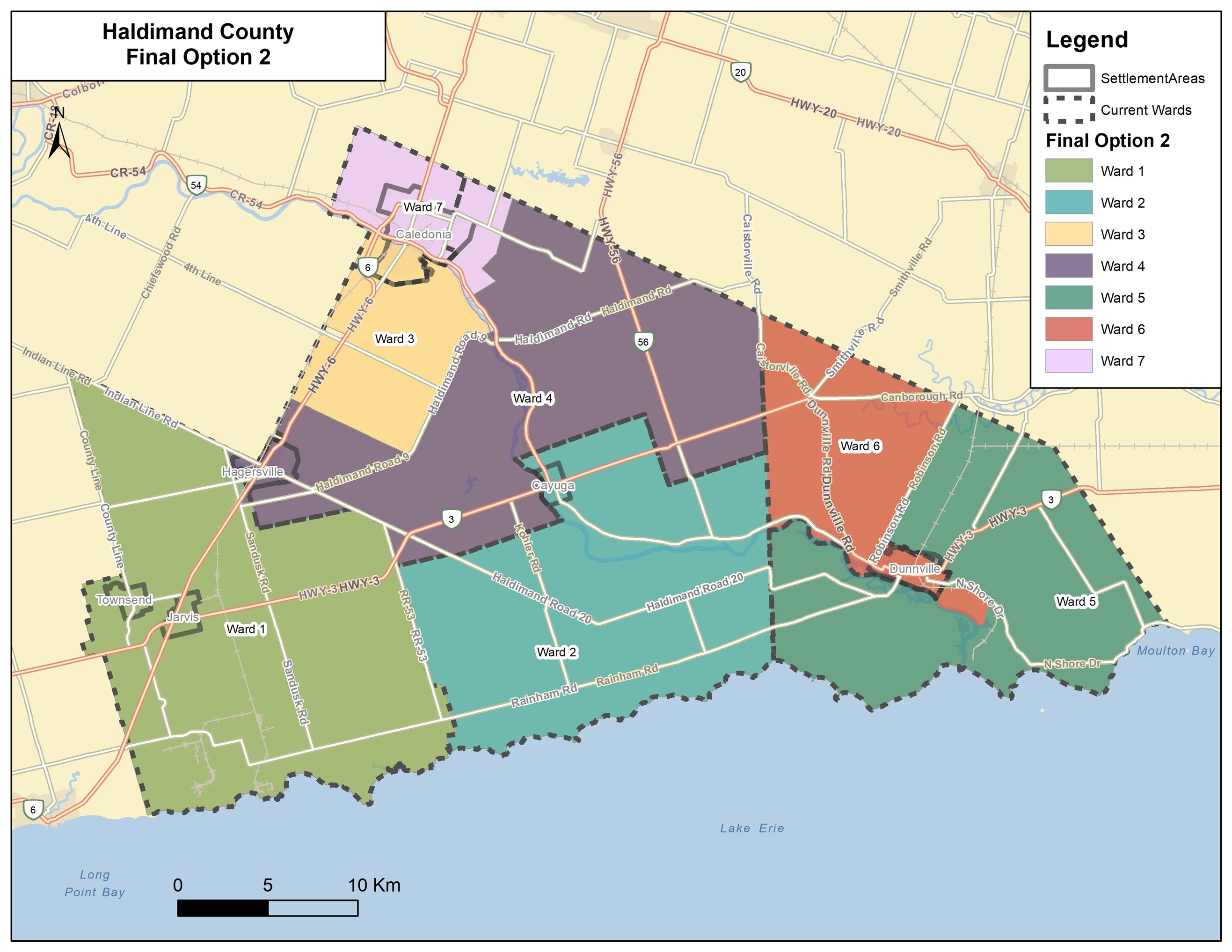
1. THAT the existing wards of Haldimand County shall be redivided into seven (7) wards as described in Schedule “A” which is attached and forms part of this by-law.
2. THAT effective for the 2026 municipal election, the composition of Council for Haldimand County shall include seven (7) Councillors with one (1) being elected within each of the seven (7) wards.
3. THAT Section 1 of this by-law shall come into force on the day set out in accordance with subsection 222(8) of the Act.
4. THAT Section 2 of the by-law shall come into force on the day set out in accordance with subsection 217(3) of the Act, subject to Section 1 of this by-law coming into force.
5. THAT By-laws 477/04 and 640/05 be repealed upon this by-law coming into force.
6. AND THAT in accordance with subsection 222(1) of the Act, this by-law prevails over the ward boundary provisions of subsection 1(1) and 1(2) of O. Reg. 94/00, but is not intended to affect or in any way alter the provisions of Section 2 of the said Regulation which describes the boundary between the Town of Haldimand (now called Haldimand County) and the Town of Norfolk (now called Norfolk County).
Schedules
Ward One (1) Description
Beginning in the northwest corner of Haldimand County where Indian Line and County Line 74 meet; thence southeast along the centreline of Indian Line to Sandusk Road. Thence south along the centreline of Sandusk Road to the centreline of Concession10 Walpole; thence east along the centreline of Concession 10 Walpole to Haldimand Road 20; thence southeast along the centreline of Highway 20 to Haldimand Road 53; thence south along the centreline of Haldimand Road 53 to Concession 3 Road; thence east along the centreline of Concession 3 Road to the northeast corner of parcel 2810158002581000000; thence south along the eastern boundary of said parcel to the southeast corner, thence west along the south boundary of said parcel to the northeast corner of parcel 2810333002492000000. Thence south in a straight line along the east boundary of parcels 2810333002492000000, and the adjacent parcel 2810333002553000000 to parcel 2810158002553050000; thence east and south along the north and east boundary of said parcel; thence crossing Rainham road, and proceeding along the east boundary of parcels 2810333002465000000 and 2810333002002050000 to the southeast corner of the latter, thence west along the south boundary of said parcel and the adjacent parcel 2810333002004000000 to Erie Street South. Thence south down the centreline of Erie Street South to Lake Erie; thence west along the southern limit of Haldimand County on Lake Erie to the western boundary of Haldimand County; thence north along the western boundary of Haldimand County to the northwest corner of Haldimand County where Indian Line and County Line 74 meet.
Ward Two (2) Description
Beginning at the intersection of Haldimand Road 53 and Concession 8 Road; thence east on the centreline of Concession 8 Road to Haldimand Road 20; thence southwesterly on the centreline of Haldimand Road 20 to Irish Line Road; thence east on the centreline of Irish Line Road to the Grand River; thence north on the southern shore of the Grand River to Townline Road East; thence east on the centreline of Townline Road East to the northeast corner of parcel 2810155003001000000; thence south along the east property lines of said parcel and adjacent parcel 2810155003057000000, bisecting parcel 2810155990010000000 and 2810155003056000000 to continue along the east boundary of parcels 2810155003057000000 and 2810155003057100000, thence crossing Highway 3 and continuing south along the east boundary of parcels 2810155003082500000, 2810155003082000000, and 2810155003106000000 to Concession 1 Road South; thence east on the centreline of Concession 1 Road South to Haldimand Dunnville Townline Road; thence south on the centreline of Haldimand Dunnville Townline Road, crossing the Grand River, to Haldimand Road 20; thence south on the centreline of Haldimand Road 20 to Haldimand Dunnville Townline Road; thence south on the centerline of Haldimand Dunnville Townline road to the southern limit of Haldimand County on Lake Erie; thence west on the southern limit of Haldimand County on Lake Erie to Erie Street South; thence north on the centreline of Haldimand Road 53 to the northwest corner of parcel 2810158002553050000; thence north along the east boundary of said property to the northeast corner; thence west to the east boundary of property 2810158002004000000; thence east following the north property boundary of said parcel east to parcel 2810158002005000000; thence east along the north property line of said parcel to the northeast corner, thence north along the east property line of parcel 2810333002002050000, and continuing north along the east boundary of parcel 2810333002465000000, thence crossing Rainham Road and proceeding to the southeast corner of parcel 2810158002553050000 and along the east and north boundary of said parcel to parcel 2810333002553000000; thence north along the east boundary of said parcel 2810333002492000000 to the south boundary of parcel 2810158002581000000. Thence east along the south boundary of said parcel to the southeast corner, thence north along the east boundary of said parcel to Concession 3 Road, thence west on the centreline of Concession 3 road to Haldimand Road 53; thence north on the centreline of Haldimand Road 53 to the intersection of Haldimand Road 53 and Concession Road 8.
Ward Three (3) Description
Beginning where the 2nd Line meets the northerly limit of Haldimand County at the Six Nations of the Grand River border; thence running northeast to the Grand River; thence running southeast on the centreline of the Grand River to Nairne Street; thence northeast on the centreline of Nairne Street to Haldimand Road 54; thence southwest on the centreline of Haldimand Road 54 to McClung Road; thence south to the Grand River; thence southwest on the south shoreline of the Grand River, to Haldimand Road 9; thence west on the centreline of Haldimand Road 9 to the Second Line; thence northwest on the centreline of 2nd Line to the north boundary limit of Haldimand County at the Six Nations of the Grand River border.
Ward Four (4) Description
Beginning at the intersection of Indian Line and Sandusk Road; thence running southwest on the centreline of Indian Line, continuing where it becomes King Street West; thence to the southerly limit of Mississaugas of the Credit First Nation border with Haldimand County; thence running northeast on the northerly limit of Haldimand Count at the border of the Mississaugas of the Credit First Nation and Six Nations of the Grand River to 2nd Line; thence running southeast on the centreline of 2nd Line to Haldimand Road 9; thence running northeast on the centreline of Haldimand Road 9 to the Grand River; thence north along the south shore of the Grand River to Abbey Road; thence northeast on the centreline of Abbey Road to Haldibrook Road; thence west on the northeasterly limit of Haldimand County to Caistorville Road; thence south on the centreline of Caistorville Road to Haldimand Dunnville Townline Road; thence south on the centreline of Haldimand Dunnville Road Townline Road to Concession 1 Road South; thence west on the centreline of Concession 1 Road south to the northeast corner of parcel 28101155003106000000; thence running north along the east boundary of said parcel and adjacent parcels 28101155003082000000, and 2810155003082500000; thence crossing Highway 3 and continuing north along the east boundary of parcel 28101155003057100000 and continuing along the east boundary of parcel 2810155003057000000; continuing north bisecting parcels 2810155003056000000 and 2810155990010000000; thence continuing north along the east boundary of parcel 2810155003058000000 and adjacent parcels 2810155003003000000 and 2810155003001000000 to Townline Road East; thence running west on centreline of Townline Road East to the Grand River; thence running south on the centreline of the Grand River to Irish Line; thence running west on the centreline of Irish Line to Haldimand Road 20; thence running northwest on the centreline of Haldimand Road 20 to Concession 8 Road; thence running west on the centreline of Concession 8 Road to Haldimand Road 53; thence running north on the centreline of Haldimand Road 53 to Haldimand Road 20; thence running northwest on the centreline of Haldimand Road 20 to Concession 10 Walpole; thence running west on the centreline of Concession 10 Walpole to Sandusk Road; thence north on the centreline of Sandusk Road to Indian Line.
Ward Five (5) Description
Beginning at Haldimand Dunnville Townline Road at the southern boundary of Haldimand County on Lake Erie; thence north on the centreline of Haldimand Dunnville Townline Road to Haldimand Road 20; thence continuing north on the centreline of Haldimand Road 20 to Haldimand Dunnville Townline Road; thence continuing north on the centreline of Haldimand Dunnville Townline Road to the Grand River; thence east on the north shore of the Grand River to Broad Creek; thence east along the centreline of Broad Creek to the Canadian Pacific Railway line; thence west on the centreline of the Canadian Pacific Railway to the east boundary of the Dunnville settlement area; thence north and west following the Dunnville settlement boundary to Highway 3/Broad Street at the northwest corner of parcel 2810023002094000000; thence northeast on the centreline of Highway 3/Broad Street to the Maple Creek Drain; thence northwest on the centreline of the Maple Creek Municipal Drain to Logan Road; thence west on the centreline of Logan Road to Concession Road East where it turns into the centreline of Concession Road West to the southeast corner of parcel 2810024006243040000, thence continuing northwest along the northeast boundary of said parcel and the northeast boundary of all adjoining properties to the northwest corner of parcel 2810024006377500000 at Robinson Road; thence north on the centreline of Robinson Road to the Haldimand County boundary at Wainfleet-Dunnville Townline Road; thence south on the Haldimand County boundary to the southwest corner of Haldimand County on Lake Erie, thence west along the boundary of the Lake Erie shoreline to Haldimand Dunnville Townline Road.
Ward Six (6) Description
Beginning at the Haldimand County northern boundary at Caistorville Road; thence south on the centreline of Caistorville Road to Haldimand Dunnville Townline Road; thence south on Haldimand Dunnville Townline Road to the Grand River; thence south on the northern shoreline of the Grand River to Broad Creek; thence east along the centreline of Broad Creek to the Canadian Pacific Railway line; thence west on the centreline of the Canadian Pacific Railway to the eastern boundary of the Dunnville settlement area; thence north and west along the Dunnville settlement boundary to Highway 3/Broad Street at the northwest corner of parcel 2810023002094000000; thence northeast on the centreline of Highway 3 to the Maple Creek Drain; thence northwest on the centreline of the Maple Creek Municipal Drain to Logan Road; thence west on the centreline of Logan Road to Concession Road East continues on the centreline of Concession Road West to the southeast corner of parcel 2810024006243040000, thence continuing northwest along the northeast boundary of said parcel and the northeast boundary of all adjoining properties to the northwest corner of parcel 2810024006377500000 at Robinson Road; thence north on the centreline of Robinson Road to the Haldimand County boundary at Wainfleet-Dunnville Townline Road; thence northwest on the Haldimand County Boundary to Caistorville Road.
Ward Seven (7) Description
Beginning in the northwest corner of Haldimand County at Sawmill Road and Onondaga Townline Road; thence southeast on the Haldimand County boundary on Sawmill Road continuing where it turns to Haldibrook Road to Abbey Road; thence south on the centreline of Abbey Road to the Grand River; thence north on the south shore of the Grand River to McClung Road and Caithness Street East; thence northwest on the centreline of Caithness Street East to Nairne Street; thence south on the centreline of Nairne Street to the south shore of the Grand River; thence northwest on the centreline of the Grand River to the Haldimand County boundary; thence north on the Haldimand County boundary to the northeast corner of Haldimand County at Onondaga Townline Road.
Contact Us
Haldimand County
53 Thorburn Street South
Cayuga, Ontario
Canada, N0A 1E0
Phone: 905-318-5932
After hours (Road, Sewer, Water or Park & Public Facilities Emergencies): 1-888-849-7345


